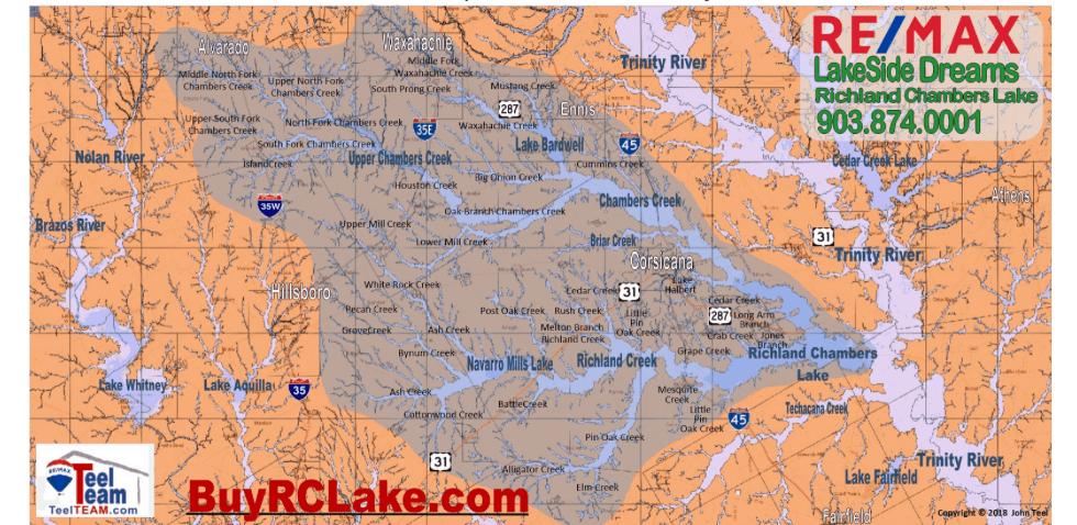

How does Richland Chambers Lake fill?
When you move to the lake some things come into focus that you never really considered before. One of those things is the water level of Richland Chambers. So what drives the lake level? Well, there are factors that affect the water level, but the #1, #2, #3, #4…. #197th factor is rainfall.
The lake level depends on rainfall in our watershed. RC Lake has a very prolific watershed covering approximately 1,947 square miles. It stretches all the way from here through Waxahachie through Cedar Hill, up to I-20 over past Venus to Alvarado, past I35W, down into Hill County through Carl’s Corner (I always wondered who Carl was) on down into Limestone County over to Coolidge and back up to Streetman. The southern edge of it is basically Tehuacana Creek which runs west to east and empties into the Trinity River south of Richland Creek.

So, when it rains here on shores of Richland Chambers it is nice, refreshing and waters the pastures but, what fills the lake is rain across our watershed.
Lake Bardwell is a Corps of Engineer lake in the Chambers watershed. Navarro Mills, also Corps lake, is to the west of Corsicana in the Richland watershed. There are several factors that determine when their spillways are opened to release water downstream. But, when they are opened and the creeks flow that is when Richland Chambers fills. I like to say “they built the lake here for a reason”.
-John Teel
Categories
Recent Posts